
2019 is over and it’s time to reflect on this past year’s paddles and offer my Top 10 choices for the year. Each year and every paddle is different. In 2019, Florida Paddle Notes has re-visited some yearly favorites as well as added a couple of new waterways with new adventures. I logged in around 300 miles this year, despite taking 6 weeks off this summer, to be home with our new puppy. The miles are not my goal…it’s the enjoyment and experiences I encounter when I do get on the water.
In 2020, my goal is to expand out a little more and add 5 or 6 new locations that I have yet to visit! I’m looking forward to another year exploring Florida’s many beautiful waterways and in the meantime, here is Florida Paddle Notes 2019 Top 10 paddle destinations...James
![]()
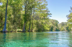
#10 – The Weeki Wachee River
Brief Overview…
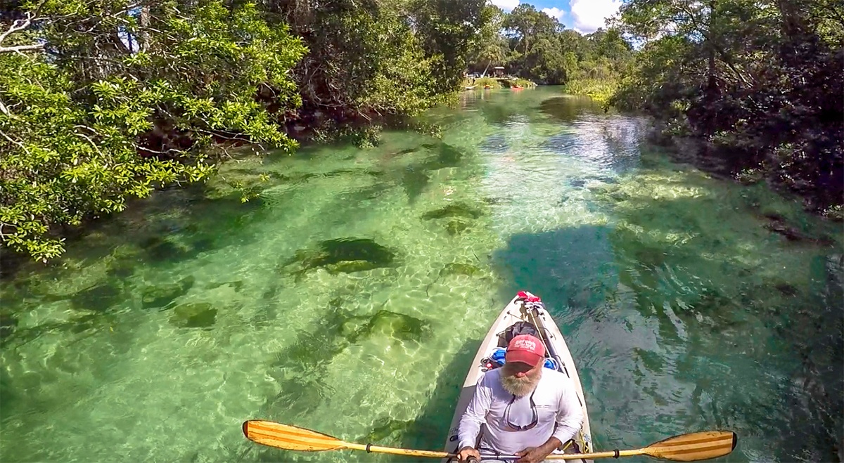
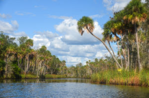
The Weeki Wachee River is a 12 mile long river, flowing in a westerly direction from Weeki Wachee to the Gulf of Mexico. The source is the deepest naturally occurring, first magnitude spring in the United States, discharging from 112 to 150 million gallons of water a day.
Designated an Outstanding Florida Waterway in 2003, the river flows through open marshes and the southern portion of the Chassahowitzka Wildlife Management Area. Wildlife is abundant along the first few miles of the river. Herons, Eagles, Egrets, Wood Storks and more call this river home. There is a diverse variety of trees from hardwoods to sub-tropicals that provide a pleasing canopy for much of the paddle. During cooler weather in winter, West Indian Manatees make their way from the Gulf of Mexico up into the river to enjoy the warmer water.
![]() Why I like this river: A very scenic river, with clear water, passing through some beautiful areas rich in vegetation and wildlife. There are several nice spots to stop and relax in the water. I like the strength of the flow as well. We have always been fortunate in avoiding the crowds by going on the weekdays during the school season and avoiding the summers. I can’t say that I’ve ever been disappointed when paddling this river.
Why I like this river: A very scenic river, with clear water, passing through some beautiful areas rich in vegetation and wildlife. There are several nice spots to stop and relax in the water. I like the strength of the flow as well. We have always been fortunate in avoiding the crowds by going on the weekdays during the school season and avoiding the summers. I can’t say that I’ve ever been disappointed when paddling this river.
Previous detailed posts for the Weeki Wachee, with maps and photos can be viewed here…
#9 – Gum Slough
Brief Overview…
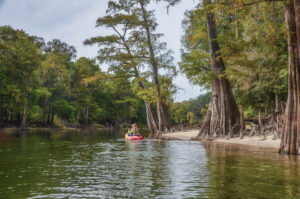
Gum Slough is a five-mile-long spring run that flows into the Withlacoochee River, near Potts Preserve. The slough, flowing through Gum Swamp and Half-Moon Wildlife Management Area, is fed from several springs known as the Gum Slough Springs Group, and the Seven Sisters Springs. These Include Wilson Head Spring, Alligator Spring, Gum Springs #1-#4 and Gum Spring Main. The slough flows in a predominantly Southwest direction from the main spring to the Withlacoochee River.
The wetlands and hammocks through which the slough flows, are characterized by numerous parallel, interlaced shallow streams, heavily canopied with Tupelo, Bald Cypress, Red Maples and Carolina Ash. Herons, Egrets, Ibis, Owls, Gators, Turtles and Osprey are usually in abundance.
Gum Slough was designated an Outstanding Florida Water in 1989.
![]() Why I like this waterway: This river was a true adventure for me. It was a long paddle, against a pretty good current but the habitat took us through a dense canopy of Ash and Tupelo, an interlaced maze of streams, requiring attention to the painted markers on the trees. The springs were beautiful! Not many places to exit the kayak along the way but we did relax in the shallow run of one of the springs. All downstream on the way back. Plan for a workout and a long day, but expect a true adventure into this beautiful swamp!
Why I like this waterway: This river was a true adventure for me. It was a long paddle, against a pretty good current but the habitat took us through a dense canopy of Ash and Tupelo, an interlaced maze of streams, requiring attention to the painted markers on the trees. The springs were beautiful! Not many places to exit the kayak along the way but we did relax in the shallow run of one of the springs. All downstream on the way back. Plan for a workout and a long day, but expect a true adventure into this beautiful swamp!
Previous detailed posts for Gum Slough, with maps and photos can be viewed here…
#8 – The Cedar Keys
Brief Overview…
The Cedar Keys are located 50 miles southwest of Gainesville, in Levy County. The group of keys are named after the Eastern Red Cedar tree, which played a predominant role during the 1800’s. Cedar Key was actually offshore from where the city is located now, on the island key of Atsena Otie. “Atsena Otie” is from the Muscogean language “acheno ota” which translates to Cedar Island. It was here that settlers established the town Cedar Key in 1842.
Scale Key is part of the Cedar Keys located 3/4 mile East of the Channel 3 Bridge and 1.2 miles northeast of Cedar Key. The Executive Documents of the 13th Congress 1847, which show that the Cedar Keys were reserved for occupation under The Armed Occupation Act of 1842. This act was to allow individuals with arms, to settle unoccupied lands in the Florida peninsula to help control any uprisings from the Seminole Indians that still remained in Florida.
Remnants from the old town, as well as a cemetery still remain on Atsena Otie. It is now managed as part of the Cedar Keys National Wildlife Refuge.
![]() Why I like the Cedar Keys: I love the saltwater and the openness of paddling to Atsena Otie. A great time to spend on a sandy beach, fish or explore the key. It is less than a mile from the launch at Cedar Key. Be mindful of the wind and tides when paddling the Cedar Keys.
Why I like the Cedar Keys: I love the saltwater and the openness of paddling to Atsena Otie. A great time to spend on a sandy beach, fish or explore the key. It is less than a mile from the launch at Cedar Key. Be mindful of the wind and tides when paddling the Cedar Keys.
Previous detailed posts for the Cedar Keys, with maps and photos can be viewed here…
#7 – Rainbow River
Brief Overview…
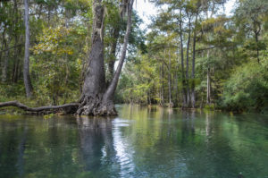
The Rainbow River is a 5.7 mile river located in Dunellon, Fl, about 20 miles southwest of Ocala, in Marion County. The headspring, Rainbow Spring, is a 1st magnitude spring that ranks 4th in the state for volume, discharging 400-600 million gallons of water a day! The spring is composed of numerous vents rather one single vent. There are many smaller springs along the river, discharging water from numerous caves, crevices and sand boils as it flows into the Withlacoochee River.
In 1972, the Rainbow River became a Registered Natural Landmark and was followed by becoming an Aquatic Preserve in 1986 and an Outstanding Florida Waterway in 1987. The river hosts an abundance of wildlife and diverse vegetation. The water clarity is extraordinary!
![]() Why I like this river: I consider this river to have the clearest water I have ever paddled on. I also enjoy the side paddle to Gissy Spring and enjoy the entire river for a pleasant paddle. Like the Ichetucknee and Weeki Wachee, these clear, spring fed rivers are best visited during the week when school is in session, due to the crowds.
Why I like this river: I consider this river to have the clearest water I have ever paddled on. I also enjoy the side paddle to Gissy Spring and enjoy the entire river for a pleasant paddle. Like the Ichetucknee and Weeki Wachee, these clear, spring fed rivers are best visited during the week when school is in session, due to the crowds.
Previous detailed posts for the Rainbow River, with maps and photos can be viewed here…
#6 – Chassahowitzka River
Brief Overview…
The Chassahowitzka River (pronounced “Chaz-wits’-kuh”) is a 5.6 miles long spring-fed river located in southwestern Citrus County, Fl. south of Homosassa Springs. It flows through the Chassahowitzka National Wildlife Refuge on it’s way to the Gulf of Mexico. The river was named after a wild variety of vining, hanging pumpkin that grew along the shoreline and translates as “hanging pumpkin”.
Chassahowitzka Spring, a 1st magnitude spring is the headwater of the river. Just East of the main vent is a group of smaller springs, some connected by caves, known as the Seven Sisters, Chassahowitzka Solution Holes, or Chassahowitzka #1, #2. There are a number of tributaries feeding into the river heading downstream.
The Chassahowitzka River is wide, shallow and slow moving and was named an Outstanding Florida Waterway.
The Chaz has an abundance of wildlife to include Otters, Ferel Pigs, Raccoons, Egrets, Herons, Eagles and Ospreys among others. Fishing is excellent. The shoreline forests are a beautiful jungle-like mix of Palms, Cedars, Red Maples, Hickories and Bay.
![]() Why I like this river: This is an adventurous, open river that I really like! It offers springs, several interesting side paddles on it tributaries and beautiful coastal landscapes of water grass and palms.
Why I like this river: This is an adventurous, open river that I really like! It offers springs, several interesting side paddles on it tributaries and beautiful coastal landscapes of water grass and palms.
Previous detailed posts for the Chassahowitzka River, with maps and photos can be viewed here…
#5 – Santa Fe River
Brief Overview…
The Santa Fe River is a slow-flowing 75-mile river in north central Florida that flows westerly into the Suwannee River near Branford Fl. It’s source is Lake Santa Fe – Little Lake Santa Fe located north of Melrose and East of Waldo.
Dozens of springs feed into the Santa Fe river many of which are located in what is called the Lower Santa Fe River. Some of the most popular springs include Poe Springs, Rum Island Spring, Gilchrist Blue, Ginnie, Devils Eye and Devils Ear.
The Santa Fe River has an abundance of wildlife to include several species of Turtles, Otters, Deer, Snakes, Herons, Egrets, Limpkins, Owls and Ospreys among others. Along the shoreline is an assortment of hardwood trees and in the lower-lying areas there are a variety of shrubs to include Spider Lilies, Atamasco Lilies, Buttonbush, Red Cardinal Flower, Yellow Burr Marigolds and Purple Asters.
A 26 mile Designated Paddling Trail runs from High Springs to Branford at the Suwannee River.
![]() Why I like this river: This river was my introduction to North Central Florida. I moved to a 5 acre tract of land at Rum Island, a popular spring on the river, in 1973. I spent many days and years since, exploring this river and it’s numerous springs. This river’s springs can become very crowded on weekends and in the summer.
Why I like this river: This river was my introduction to North Central Florida. I moved to a 5 acre tract of land at Rum Island, a popular spring on the river, in 1973. I spent many days and years since, exploring this river and it’s numerous springs. This river’s springs can become very crowded on weekends and in the summer.
Previous detailed posts for the Santa Fe River, with maps and photos can be viewed here…
#4 – Ocklawaha River
Brief Overview…
The 74 mile Ocklawaha River is a must paddle for those interested in ‘Old Florida’. It’s history is rich as are the wildlife and surrounding forests. The river is the principal tributary of the St. Johns River, while it’s key tributary is the Silver River, near Silver Springs.
The Ocklawaha River has several personalities of habitat, through narrow canopied sections of Cypress, Maple, Tupelo and more, to wide open expanses of aquatic grasses and vegetation. Wildlife is abundant throughout the river.
The river has a storied history of steamboats and controversies over the Florida Barge Canal and the Rodman Dam, details of which can be read in the link below to previous posts on Florida Paddle Notes.
![]() Why I like this river: I like several sections of The Ocklawaha River below the Rodman Dam. It is a nice lazy river with Bald Cypress and Ash, long strands of Spanish Moss waving in the breeze. Plenty of wildlife to include numerous gators and several spots to pull over and relax. It is quite interesting to paddle during the Rodman Dam drawdown!
Why I like this river: I like several sections of The Ocklawaha River below the Rodman Dam. It is a nice lazy river with Bald Cypress and Ash, long strands of Spanish Moss waving in the breeze. Plenty of wildlife to include numerous gators and several spots to pull over and relax. It is quite interesting to paddle during the Rodman Dam drawdown!
Previous detailed posts for the Ocklawaha River, with maps and photos can be viewed here…
#3 – Ichetucknee River
Brief Overview…
The Ichetucknee River is a 6 mile long, spring-fed crystal clear river, flowing through Columbia and Suwannee counties in North Central Florida. The river is part of the Ichetucknee Springs group that include nine named springs contributing a total of 212 million gallons of water per day.
The river flows through floodplain forests and shaded hammocks on it’s way to the Santa Fe River, which then flows into the Suwannee River and on to the Gulf of Mexico. The water is clear and a year round 72°.
Ichetucknee Springs became a State Park and in 1972, Ichetucknee Spring was declared a National Natural Landmark.
![]() Why I like this river: The clear water, the shadiness from the canopy of trees, a nice flow, interesting limerock formations along the way all make this an ‘intimate’, very relaxing paddle. As with the other spring fed rivers, it is extremely crowded when school is not in session!
Why I like this river: The clear water, the shadiness from the canopy of trees, a nice flow, interesting limerock formations along the way all make this an ‘intimate’, very relaxing paddle. As with the other spring fed rivers, it is extremely crowded when school is not in session!
Previous detailed posts for the Ichetucknee River, with maps and photos can be viewed here…
#2 – Silver River
Brief Overview…
The Silver River is a 5.5 mile spring-fed river located about 6 miles East of Ocala in Marion County, Fl. and flows into the Ocklawaha River. Silver Springs is a 1st magnitude spring and source of flow to the Silver River, discharging over 500 million gallons of water a day!
In addition to the main spring there are several other springs in this basin, located along the river, that all add to the flow. The Silver river is rich with wildlife, to include numerous varieties of Turtles, Ospreys, Anhingas, Cormorants and Alligators among others. The Rhesus monkeys are predominant along the shoreline.
The Silver River is designated as an Outstanding Florida Waterway.
![]() Why I like this river: Another simply beautiful paddle! The forested shoreline accented with seasonal wildflowers and water plants, the clear water and the abundant wildlife. A treat also lies below the surface with several caves, artifacts and shipwrecks visible from the surface. There is a nice flow and makes for a simply pleasant paddle.
Why I like this river: Another simply beautiful paddle! The forested shoreline accented with seasonal wildflowers and water plants, the clear water and the abundant wildlife. A treat also lies below the surface with several caves, artifacts and shipwrecks visible from the surface. There is a nice flow and makes for a simply pleasant paddle.
Previous detailed posts for the Silver River, with maps and photos can be viewed here…
#1 – Juniper Creek Run
Brief Overview…
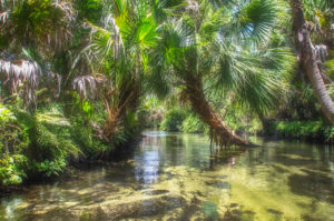
Juniper Creek Run is a 7 mile winding waterway originating from Juniper Springs in the Ocala National Forest, Marion County. The creek flows through several sections of beautiful, diverse forest and wilderness eventually flowing into the St. Johns River.
The current is swift in the upper section, slowing down somewhat as it flows through the Juniper Prairie Wilderness. There are several places mid-way down the creek to rest in the cool water with a hard sandy bottom. As the creek begins an easterly direction about 3/4 of the way downstream, there is a short but fun rapid to liven up the paddle.
Juniper Creek Run is listed as one of the top 25 canoe runs in America by ReserveAmerica.
![]() Why I like this creek run: This is a paddle through old Florida! The clear spring water creates a swift current, flowing over patches of white sand, winding and twisting through tropical palms and large cypress. From a shady canopy to a more open wilderness with a small stretch of rapids! It hard to beat this paddle and it is always a treat, hence #1.
Why I like this creek run: This is a paddle through old Florida! The clear spring water creates a swift current, flowing over patches of white sand, winding and twisting through tropical palms and large cypress. From a shady canopy to a more open wilderness with a small stretch of rapids! It hard to beat this paddle and it is always a treat, hence #1.
Previous detailed posts for Juniper Creek Run, with maps and photos can be viewed here…
Honorable Mention
Bulow Creek North ~ Okefenokee Swamp ~ Rock Springs Run
![]()